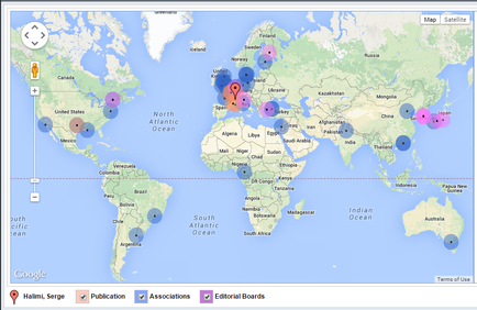
OIDA Image Collection
Filters:
Reset 
A map of the world showing the locations of various media outlets in different countries. The map is color-coded with different shades of blue representing different media outlets. The countries are labeled with their respective names such as North Atlantic Ocean South Atlantic Ocean and Indian Ocean. There are also several red dots scattered across the map indicating the locations where media outlets are located. At the top of the image there is a navigation bar with various options such as Google Publication Associations and Editorial Boards. Below the navigation bar there are two buttons - "Publishing" and "Editorial Boards". The map also has a legend at the bottom which explains the different colors used in the map.

Description Generated using AI

A map of the world showing the locations of various media outlets in different countries. The map is color-coded with different shades of blue representing different media outlets. The countries are labeled with their respective names such as North Atlantic Ocean South Atlantic Ocean and Indian Ocean. There are also several red dots scattered across the map indicating the locations where media outlets are located. At the top of the image there is a navigation bar with various options such as Google Publication Associations and Editorial Boards. Below the navigation bar there are two buttons - "Publishing" and "Editorial Boards". The map also has a legend at the bottom which explains the different colors used in the map.

Type Generated using AI

Category

We encourage you to view the image in the context of its source document(s) and cite the source(s) when using these images. However, to cite just this image alone, click the “Cite This Image” button and then paste the copied text.

Information copied to your clipboard:

"A map of the world showing the locations of various media outlets in different countries. The map is color-coded with different shades of blue repres...