


Title
Description
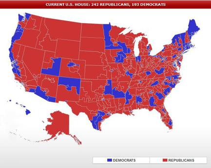
This is a color-coded map of United States Congressional districts during the 112th United States Congress (held from January 3 2011 to January 3 2013) as a result of the 2010 United States elections (of November 2 2010). Districts that elected a Republican representative to the United States House of Representatives (242) are in red and districts that elected a Democratic representative to the United States House of Representatives (193) are in blue. These are the Representatives that served during the second half of the first term of President of the United States Barack Obama.
Type 
Category
-
Date
2012
Collection
We encourage you to view the image in the context of its source document(s) and cite the source(s) when using these images. However, to cite just this image alone, click the “Cite This Image” button and then paste the copied text.