


Title
Description
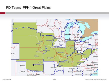
This is a map of a central portion of the United States showing the boundaries of the PPN4 Great Plains PD Team. That includes all of Indiana Kansas Kentucky Missouri Nebraska Oklahoma South Dakota Tennessee and West Virginia as well as parts of Illinois (its southern half & some countries in the northwest part bordering Iowa). There are both red lines and blue lines on the map but their significance is unclear and the boundaries between states is not always obvious.
Type 
Category
Source 1 of 2
-
Date
2015
Collection
-
Date
2014
Collection
We encourage you to view the image in the context of its source document(s) and cite the source(s) when using these images. However, to cite just this image alone, click the “Cite This Image” button and then paste the copied text.