


Title
Description
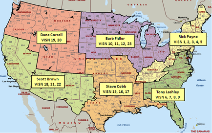
This is a map of the continental United States divided into 6 regions that usually (but not always) follow state lines. For example most of the Southeastern United States (Alabama Florida Georgia North Carolina South Carolina and Virginia) is attributed to Tony Lashley (a regional manager?) comprising VISN 6 7 8 and 9 (the boundaries of which are not shown). Other regions include the East Coast (Rick Payne) the Midwestern states (Barb Fidler) the West South Central states (Steve Cobb) the Southwestern states (Scott Brown) and the Pacific Northwest & Great Plains (Dane Correll).
Type 
Category
Source 1 of 2
-
Date
2013
Collection
-
Date
2014
Collection
We encourage you to view the image in the context of its source document(s) and cite the source(s) when using these images. However, to cite just this image alone, click the “Cite This Image” button and then paste the copied text.