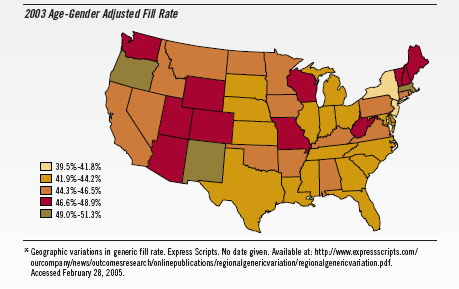
A map of the United States with the title "2003 Age-Gender Adjusted Fill Rate". The map is color-coded with different shades of orange representing different percentages. A key shows the percentages range from 39.5%-41.8% for the lightest shade of orange to 49%-51.3% for the darkest shade of orange. Text at the bottom of the image reads "Geographical variations in generic fill rate. Express Scripts. No date given." with a website where the map is also available.
Category
Source 1 of 2
-
Date
2006
Collection
-
Date
2006
Collection
We encourage you to view the image in the context of its source document(s) and cite the source(s) when using these images. However, to cite just this image alone, click the “Cite This Image” button and then paste the copied text.


