


Title
Description
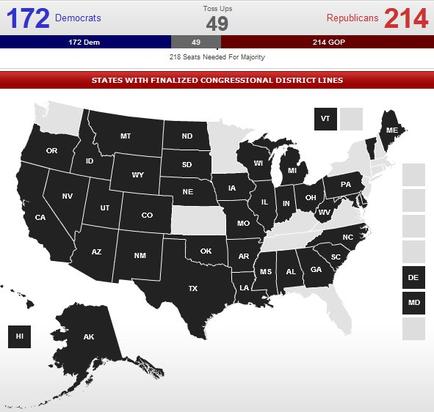
This is an undated map of the United States color-coded to indicate whether individual states have finalized their Congressional district lines in advance of an upcoming United States House of Representatives election. About 2/3 of states are in black (with their USPS state abbreviations in white at their center) with about 1/3 of states in light gray (without their USPS state abbreviations); there is no key to explain what the colors represent. The top of the map includes information about the political affiliations of presumptive members of the next United States House of Representatives : 214 Republicans are expected to win 172 Democrats are expected to win and 49 seats are toss ups (meaning that Republicans will have to win only 4 of those swing state races to secure a majority (comprising 218 or more seats)).
Type 
Category
-
Date
2012
Collection
We encourage you to view the image in the context of its source document(s) and cite the source(s) when using these images. However, to cite just this image alone, click the “Cite This Image” button and then paste the copied text.